Umfassende Informationen und Publikationen (in englischer Sprache) finden Sie auf nachfolgenden Akkordeon-Seiten.
-
General Overview
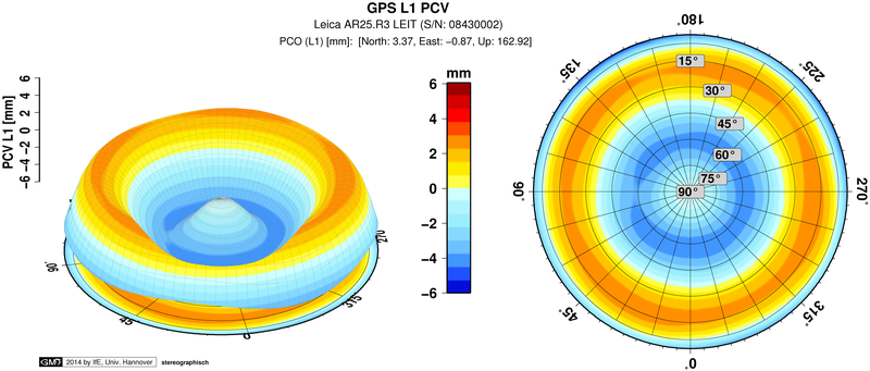
The point of reception of the GPS signal at the antenna is not homogenous. This phase error is a function of the signal's direction and varies with azimuth and elevation. The magnitude of the phase center variations (PCV) typically spans a range of mm to cm. The neglection of this antenna behavior can lead to baseline errors between mm and cm. It can even reach up to 10 cm for the height component. The different error magnitudes of the effects are due to differences of measurement setups and following GPS processings (antenna types, mixed baselines, used linear combination, estimation of tropospheric parameters, network type, kinematic applications, used elevation angle, measurement time, engineering applications, rotated/tilted antennas, type and quality of PCV correction ...).
A widely used correction for the PCV is a pure offset. But the offset estimation depends on the elevation mask and the location/constellation/multipath. Furthermore, there are different definitions of the offset (3D offsets relativ to a reference antenna, 2D horizontal absolute offsets + vertical relative offset, minimum conditions). An absolute 3D offset can only be determined with the help of rotations AND tilts of the antenna. Therefore, offsets are only a rudimentary and approximate correction. A complete correction modell including PCV should be used in precise applications.
The most common calibration type is the relative field calibration. The setup is quite simple. Reference coordinates are in most cases necessary. The results for the PCV of the tested antenna are relative to a reference antenna. Per definition, the PCV of this reference antenna are set to zero and the offsets are also fixed. The typical reference antenna for the relative field calibration is the AOAD/M_T choke ring antenna (e.g. IGS/NGS). Because of the influence of site multipath and the insufficient covering of the antenna hemisphere with observations, typical results for the PCV corrections are only elevation dependent and have a minimum elevation mask of 10 degrees. Due to the "lack" of absolute PCV information, the corrections are not sufficient for networks with differently orientated antennas (large networks, engineering applications).
![]()
![]()
![]() ©
IfE / V. Böder
©
IfE / V. Böder
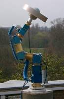
Robot of the Institut für Erdmessung (IfE) in use for absolute Antenna Field Calibration. The picture shows the robot with the calibrated Allan Osborne Dorne Margolin (AOA_DM_T) Antenna (former Null Antenna for relative calibrations). -
Absolute PCV Field Calibration
Basics and Procedure
Starting point for the development of this procedure was, that existing field calibrations were only relative (refering to a reference antenna) and correlated with the site (multipath influence and satellite constellation, i.e. northern hole). The goals were
- separation of multipath and PCV
- absolute results independent of a reference antenna
- high resolution of the PCV
- field procedure.
The realization has two features to handle the problems "relative" and "multipath influence". First of all, in order to get the absolute PCV information, the test antennas are rotated AND inclined. Secondly, differences between observations with identical multipath effects are used to eliminate site correlations
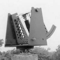
Antenna Mount
(a)
(b)
(c)
During the first development phase of the project we used the two mounts shown above (a, b). In order to achieve a better stability and precision, the current procedure makes use of a robot (c). Considerable efforts were necessary to develop an error model for the robot. The observations for this modell are derived from a tachymetric measurement system (TMS). Beside an exactly known position due to the precise robot and the high number of possible rotations and tilts, another advantage is the possibility of an automation of the calibration procedure
-
Multipath Elimination and PCV Estimation
The satellite constellation repeats after a mean sidereal day. In case of identical conditions (geometry, weather, surfaces ...), also multipath effects repeat with the same period. Thus, with the pre-conditions fulfilled, day time differences eliminate the multipath influence. Since the PCV information is elimated also, the antenna has to be rotated and tilted on one of the two measurement days. The difference of the PCV between the rotated/tilted position and the fixed position will be the observable for the PCV determination.
- NEW - The multipath elimination approach has been improved within the second phase of the project. The current calibrations are a real-time procedure without a static reference day. The multipath conditions between close measurement epochs are identical. Therefore, the difference between epochs can eliminate the effects (the realization within the software uses the correlation in time of the multipath). Finally, with both possibilities for the multipath elimination/reduction, spherical harmonic functions serve for the PCV estimation. -
Advantages of the Absolute PCV Fild Calibration
There are several advantages of the absolute PCV field procedure:
- absolute PCV (L1, L2, GPS, Glonass) in real-time
- independent of reference antenna and reference coordinates
- elimination of multipath
- precise robot, exactly known reference point (pivot)
- very good coverage of the whole antenna hemisphere with observations
- automated measurement program
- PCV down to elevation zerosignificant azimuthal PCV.
The high resolution of the PCV and the possibility to estimate reliable and repeatable azimuthal PCV is based on the automation of the measurement program. With the help of the robot, there are between 4000 and 7000 different positions (standard procedure) of the antenna. The measurement program changes with the actual satellite constellation. Thus, a total coverage of the whole antenna hemisphere is reached. Furthermore, a dynamical elevation mask is used (only satellites in high elevations) within the observation procedure.
With the presented procedure (especially through the use of a highly precise and calibrated robot and the automation of the measurements), very precise and reliable PCV corrections can be derived even down to elevation zero and also for azimuthal PCV. The results have been independently confirmed through measurements
- with different robots
- at different sites
- on different days.
-
Effects, Large Networks, Engineering Applications
The consideration of absolute PCV corrections plays an important role for precise GPS coordinate determination in several fields of application. Within large networks, simultaneously received satellite signals differ in their directions, because of the baseline length and the different orientation of the antennas. Absolute PCV are needed for this observation constellation. Relative PCV information is not sufficient (relative PCV are zero for identical antenna types, but no corrections are obviously insufficient for differently orientated antennas). The other main advantage of absolute PCV is their high resolution (-1- repeatability, -2- significant results for azimuthal PCV, -3- PCV information down to elevation zero). This information is needed for a variety of precise GPS applications, as for example in engineering surveys (e.g. inclined antennas in railroad surveying or machine guidance), in reference networks with mixed antenna types of user and provider and also for "standard" processing of regional networks (observations lower than 10 degree elevation contribute to a better separation of troposphere and height).
The AOAD/M_T choke ring antenna is the most common antenna type within the global network of the International GPS Service (IGS). Furthermore, it serves as the reference antenna for relative PCV calibrations. This group already presented some examples with absolute PCV for the AOAD/M_T (beside other mixed antenna applications) verifying the functionality and the effects of absolute PCV -
Separation of absolute PCV from other errors (satellite antenna / troposphere / coordinates)
For the verification of the absolute PCV our group did not carry out direct comparison of network results with ITRF, since the ITRF implies VLBI, Laser AND also GPS results. It is almost impossible to separate the individual error terms from PCV effects and a (sub-) mm true reference is generally not available. Our subsumtive way to verify the absolute PCV - correctness and effects - always avoids most error components and refers to a well known reference:
- Mixed short baseline: Mixed short baseline applications, including use of the ionospheric free linear combination and estimation of tropospheric parameter, and the comparison with the precisely known reference coordinates.
- Large network processing: Comparison of two solutions of large network processing (identical antennas AOAD/M_T, precise ephemeris, ionospheric free linear combination, tropospheric parameter). The only difference in the processing (identical options/parameter) are the introduced absolute PCV in one solution. The difference reveals a sort of scale in the order of 0.014 ppm (still, it is a first order effect for long observations; there are also constellation dependencies), which shows the effect of neglected absolute PCV information.
- Large network simulation: In order to compare the coordinates of a large network with a true reference, we conducted a simulation with a rotated and inclined antenna on a known short baseline. There are no effects due to other error sources (satellite, atmosphere, coordinates). Therefore, a separation of the effect can be easily done, while comparing the results using absolute PCV with precisely known reference coordinates. Height differences are shown in the next table. The AOAD/M_T antenna was inclined +/- 5 degree (roughly corresponding to about 550 km network extension) and also rotated (using an antenna mount; will be repeated with a more extensive measurement program with the robot). We compared the solution with no corrections (comparable to actual processing using relative PCV in a network like IGS) as well as the one with introduced absolute (orientated!) PCV with known reference coordinates. Errors in the range of 1 cm showed up without absolute PCV. Using the absolute PCV, only differences in the mm-range compared to the reference coordinates can be seen.


 ©
IfE / T. Kersten
©
IfE / T. Kersten


