5GAPS: 5G Access to Public Spaces
| Led by: | Prof. Dr.-Ing Steffen Schön |
| E-Mail: | baasch@ife.uni-hannover.de |
| Team: | Kai-Niklas Baasch, M.Sc. |
| Year: | 2022 |
| Funding: | Bundesministerium für Digitales und Verkehr (BMDV) - 45FG121_F |
Overview and objective of the project
In a collaborative project funded by the German Federal Ministry of Digital Affairs and Transport (BMDV), IfE is working with various partners from public and private institutions to research the development of a digital twin of the city of Hannover. This is to be made possible by the latest mobile communications standard 5G New Radio (NR), which allows the transmission of large amounts of data. The goal is to digitally map Hannover's public spaces in a multi-dimensional spatio-temporal coordinate system in real time.
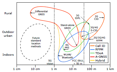
As part of the project, the IfE is investigating the positioning possibilities of the terrestrial mobile radio network. The need for fast and data-intensive communication leads to an increasingly widespread installation of the 5G NR network. Although 5G NR is not specifically designed for localization, its variable signal structure promises accuracy comparable to GNSS. Therefore, 5G NR can be an alternative or complement for absolute positioning when GNSS signals are not available or their accuracy is limited by the environment. To investigate the positioning capabilities and analyze the accuracy of the signal structures and localization algorithms, a simulation environment is first created. Based on the obtained knowledge, the results will be validated in real experiments.


