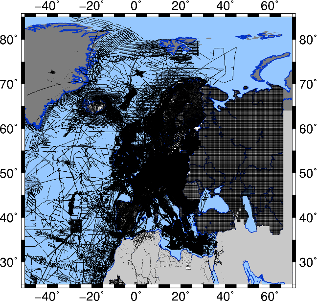
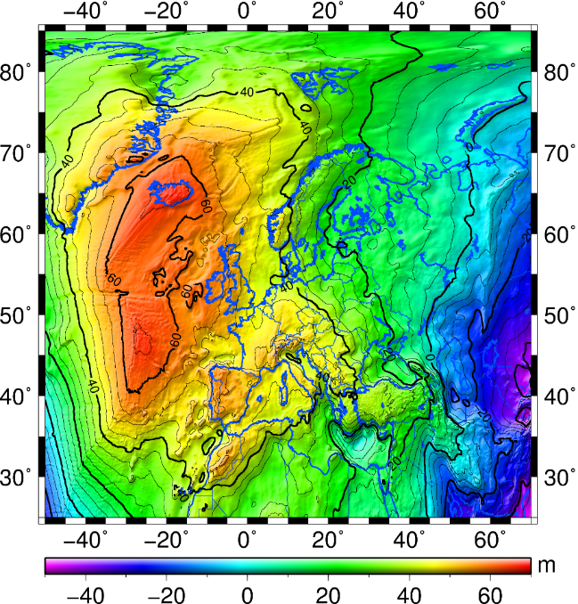
European geoid and quasi-geoid calculations began at the Institute of Geodesy (IfE) in the early 1980s with the help of mean gravity values. From the mid-1980s onwards, point gravity values were increasingly combined with digital topography models and global satellite gravity field solutions. Based on local to regional research, corresponding continental calculations for Europe were carried out from the beginning of the 1990s. This work has been carried out since 1990 with the support of the International Association for Geodesy (IAG). From 1990 to 2003 IfE served as the computing centre of the IAG Geoid Subcommission for Europe, from 2003 (with the implementation of a new IAG structure) until 2011 this work was supported in the form of an IAG project of Commission 2 CP2.1 - European Gravity and Geoid Project (EGGP), and since 2011 this task has been continued within the framework of an IAG Subcommission 2.4a Gravity and Geoid in Europe.
With the support of the IAG, gravity and topographic data were regularly updated and computed in combination with current satellite gravity field models into high-resolution geoid- and quasigeoid models.
The following gravimetric solutions became more important:
- EGG1997 (European Gravimetric (Quasi)Geoid 1997),
see Denker and Torge (1998), - EGG2008,
see Denker (2013), - EGG2015,
see Denker et al. (2018).
 ©
IfE / H. Denker
©
IfE / H. Denker

 ©
IfE / H. Denker
©
IfE / H. Denker
References
-
(1998): The European Gravimetric Quasigeoid EGG97 - An IAG supported continental enterprise, In: Forsberg, R., Feissel, M., Dietrich, R. (eds.), Geodesy on the Move – Gravity, Geoid, Geodynamics and Antarctica, IAG Scientific Assembly, Rio de Janeiro, Brazil, September 3-9, 1997, International Association of Geodesy Symposia 119: 249-254, Springer Verlag, Berlin, Heidelberg. | File |
DOI: 10.1007/978-3-642-72245-5_36
-
(2013): Regional gravity field modeling: Theory and practical results, Monograph in: Xu G. (ed.), Sciences of Geodesy – II, Chapter 5: 185-291, Springer Verlag, Berlin, Heidelberg
DOI: 10.1007/978-3-642-28000-9_5
-
(2018): Geodetic methods to determine the relativistic redshift at the level of 10-18 in the context of international timescales – A review and practical results, Journal of Geodesy 92: 487-516
DOI: 10.1007/s00190-017-1075-1


